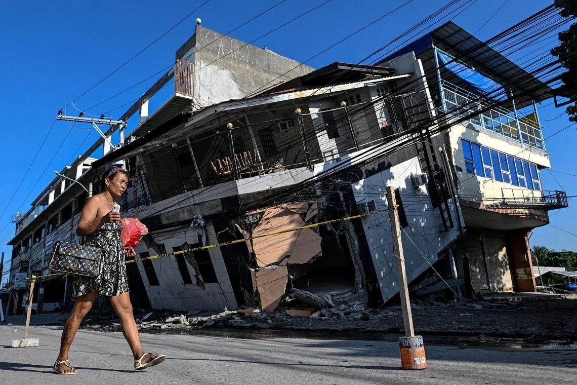
The June 8 earthquake that devastated Mindanao in the southern Philippines has left an indelible mark not just on the communities it struck, but on the very geography of the region. The 7.8-magnitude quake, originating from tectonic shifts along the nearby Cotabato Trench, triggered a rare phenomenon known as coastal uplift that has fundamentally transformed stretches of shoreline, leaving residents struggling to recognise the landscapes they have inhabited for generations. The disaster claimed at least 76 lives on the island while triggering the geological upheaval that now defines the aftermath as much as the initial devastation.
Witnesses to the transformation describe a surreal experience watching the coastline change in real time. Arsenio Butil Jr., a fisherman and pastor living in Glan, Sarangani province, recounted the moments when the earthquake struck and he began to observe the shoreline's dramatic metamorphosis. As the ground shook beneath his feet, the water receded from the coast multiple times, a phenomenon he watched with a mixture of awe and terror. The scale of the panic was immediate and profound, as residents grappled with the unprecedented nature of what was unfolding before their eyes. Fish that had been swimming moments before lay dying on exposed surfaces as the seabed rose and the water's edge relocated far from where it had always been.
The mechanism driving this coastal transformation is rooted in the collision of tectonic plates deep beneath the Philippine archipelago. The Cotabato Trench, positioned as close as 50 kilometres off the coast of Mindanao, is a zone of constant geological activity where the Pacific Plate descends beneath the Philippine Plate. This subduction process generates significant seismic energy, and the June 8 earthquake released forces powerful enough to thrust substantial sections of the seafloor upward. According to Nane Danlag, a seismologist at the Philippines' seismology centre, the seabed rose by approximately two metres, extending the shoreline by around 200 metres in some locations. The affected zone stretches across nearly 100 kilometres between two towns, creating a wall of jagged, now-lifeless coral that runs for kilometres in both directions.
The geological phenomenon at work represents a continuous process that operates over millennia, as Danlag explained to international observers. What residents are witnessing is not an anomaly but rather a manifestation of the long-term dynamics that have shaped the Philippine landscape throughout human history. The coastal uplift is permanent—there will be no reversal of the seabed's ascent—and marks a definitive change in the geography that coastal communities must now learn to navigate. This geological reality, while perhaps intellectually comprehensible to scientists, confronts local populations with a tangible and disorienting loss of familiarity with their home environment.
The economic and social consequences of this transformation extend far beyond the immediate earthquake damage. Communities that depended on fishing have found their boats stranded on the wrong side of the newly formed coral barrier, unable to access the deeper waters they once reached. The resort industry, which relies on the region's coastal attractions, faces an uncertain future as the white sand beaches that drew tourists are now separated from the water by expanses of exposed, jagged coral. Staff at Isla Jardin del Mar resort have watched their primary selling point—easy access to pristine seawater for swimming—become inaccessible almost overnight. The shallow waters and unforgiving terrain that now characterise the coast present obstacles that will require significant investment and planning to overcome.
Psychological trauma compounds the physical displacement caused by the earthquake and coastal changes. More than 100 residents, including men, women and children from nearby villages, remain encamped in the hills above their destroyed homes, reluctant to return despite the passage of time. Datu Atom Malimpnig, a local Maguindanaon chieftain, articulated the profound anxiety that grips the displaced population. Beyond the fear of further earthquakes lies a deeper apprehension: the changed coastline has sparked widespread conviction that a tsunami might strike at any moment. The residents' perception that the transformation of the seabed represents a harbinger of additional catastrophic events has effectively imprisoned them in a state of perpetual vigilance, making the hilltop encampment feel like the only safe refuge available.
The seismic context surrounding the June 8 earthquake suggests that the danger may not have fully subsided. The Cotabato Trench has been subject to intense monitoring because of its history of generating powerful earthquakes and because of precursory warning signs that emerged in preceding months. In January, seismologists recorded a swarm of thousands of small tremors across the region, a phenomenon that the United Nations Disaster Risk Reduction Office flagged in a report released in mid-May as a potential precursor to a major seismic event. Those warnings proved prescient when the 7.8-magnitude quake occurred weeks later. Since the initial earthquake, the region has experienced more than 8,500 aftershocks, including a 5.4-magnitude tremor that struck while officials were assessing the damage. This ongoing seismic activity keeps residents on edge and provides constant reminders of the tectonic forces at work beneath the surface.
The structural damage to homes and infrastructure adds another layer of concern for those considering whether to rebuild. Butil Jr. noted that the ground in his neighbourhood remains fractured with long cracks that extend across significant distances, creating hazardous conditions for anyone attempting to construct new dwellings. The physical integrity of the land itself has been compromised, and additional earthquakes of comparable magnitude could cause further catastrophic damage to any structures built on these compromised foundations. This reality has created a paralysis in the rebuilding process, as residents balance their desire to return home against the rational fear that doing so might expose them and their families to severe danger.
The disaster highlights the vulnerability of regions situated on major tectonic boundaries and the complex challenges faced by communities that must rebuild in the aftermath of not just earthquake damage but permanent geographical transformation. For Southeast Asian countries located in the Pacific Ring of Fire, including the Philippines, Indonesia, and others, the June 8 earthquake serves as a sobering reminder of the geological forces that shape the region and the need for robust disaster preparedness infrastructure. The combination of structural damage, psychological trauma, economic displacement, and ongoing seismic activity creates a multifaceted humanitarian challenge that extends far beyond immediate relief efforts. Communities must not only reconstruct buildings and infrastructure but also reimagine their relationship with landscapes that have fundamentally changed and may continue to evolve unpredictably.
Government responses and international aid have provided essential support to displaced populations, with aid workers distributing supplies to those sheltering in temporary encampments. However, the long-term recovery process faces significant obstacles. Residents cannot simply return to their former lives because those lives were anchored to specific geographical relationships—proximity to fishing grounds, accessibility of beaches, safety of particular locations—that no longer exist in the same form. The emergence of a new coastline has rendered obsolete not just physical infrastructure but also the mental maps and practical knowledge systems that communities have developed over generations. Planning for sustainable reconstruction will require not just engineering expertise but also meaningful engagement with local populations to help them reimagine their futures in a transformed landscape.