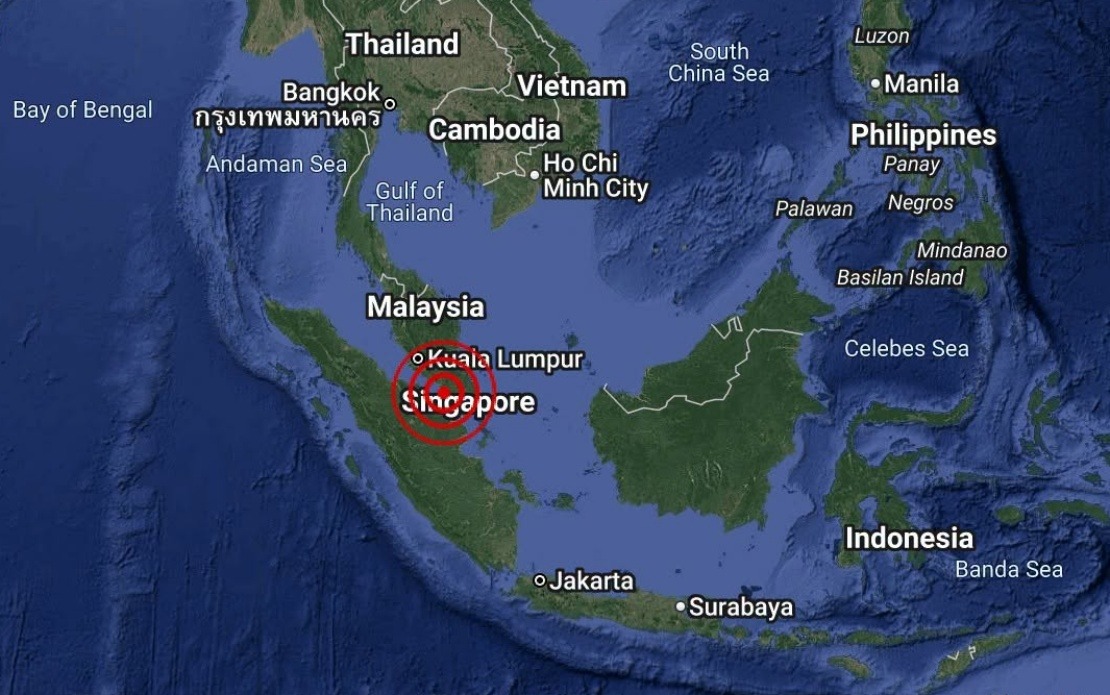
A modest earthquake measuring 3.1 on the Richter scale rattled the offshore waters near Batu Pahat in Johor on August 25, with authorities confirming there was no immediate threat to coastal communities or shipping lanes in the region. The tremor struck at 4.12 pm local time, with its epicentre positioned approximately 18 kilometres south-west of Batu Pahat at coordinates 1.7 degrees north and 102.8 degrees east, placing the disturbance firmly in Malaysian waters.
The Malaysian Meteorological Department, through its National Weather and Earthquake Operations Centre, swiftly issued a reassurance that the seismic event posed no danger to Malaysia in the form of a tsunami. This rapid assessment is part of MetMalaysia's standard protocol for monitoring and evaluating all recorded seismic activity in the region, ensuring public safety and maintaining maritime awareness across the country's waters.
Batu Pahat, situated on the southern coast of Johor, remains one of Malaysia's more seismically active zones due to its geological position and proximity to the Sunda Strait, which separates Malaysia from Indonesia. While earthquakes in the region are not uncommon, most are of low magnitude and cause minimal disturbance to residents or infrastructure. This particular tremor's magnitude of 3.1 falls within the range of earthquakes that are generally not felt by the general population, though sensitive seismic equipment deployed across the country typically records such events.
For Malaysian residents and maritime operators, understanding the distinction between earthquake magnitude and tsunami risk is crucial. A moderate earthquake occurring offshore does not automatically trigger a tsunami; the depth of the epicentre, the type of geological movement, and the volume of water displaced all factor into whether a tsunami poses a genuine hazard. MetMalaysia's immediate determination that no tsunami threat existed reflected a careful assessment of these variables based on real-time seismic data.
The monitoring capabilities demonstrated in this instance underscore Malaysia's commitment to disaster preparedness in a region where multiple natural hazards converge. The country's earthquake monitoring network, operated by MetMalaysia in coordination with international seismic centres, provides continuous surveillance of tectonic activity throughout Southeast Asia. This infrastructure became particularly vital following the catastrophic 2004 Indian Ocean earthquake and tsunami, which claimed thousands of lives across the region and prompted significant upgrades to warning systems across the Indian Ocean and beyond.
For Johor residents, particularly those in Batu Pahat and surrounding coastal settlements, such seismic events serve as periodic reminders of the region's dynamic geological nature. While the August 25 earthquake caused no reported damage or disruption to daily life, it reinforces the importance of maintaining public awareness about earthquake safety and tsunami preparedness protocols that have been established throughout Malaysia's coastal regions.
The incident also highlights the role of real-time geophysical monitoring in modern disaster management. Within minutes of the earthquake occurring, MetMalaysia's automated systems detected the event, calculated its parameters, and determined the absence of tsunami risk—a process that would have taken hours just two decades ago. This rapid response capability is essential for maintaining confidence in official warnings and ensuring that resources are not unnecessarily mobilized for false alarms, while guaranteeing that genuine threats receive immediate attention.
From a maritime perspective, the waters off Batu Pahat support significant shipping traffic and fishing activities, making accurate seismic assessment particularly important for the region's economic interests. Fishing vessels, cargo ships, and tankers operating in the Strait of Malacca and surrounding waters depend on reliable information about seismic and weather-related hazards. MetMalaysia's swift notification to relevant maritime authorities ensures that vessels can proceed with normal operations without unnecessary concern.
The broader context of earthquake monitoring in Malaysia reflects the country's position within the Pacific Ring of Fire's extended influence zone. While Malaysia itself does not sit directly on major tectonic plate boundaries, it remains vulnerable to seismic activity originating from nearby subduction zones in Indonesia and the Philippines. Earthquakes originating in Indonesian waters, particularly those involving the Sumatra-Java subduction zone, pose the most significant regional tsunami risk, necessitating continuous vigilance and sophisticated early warning systems that MetMalaysia maintains as part of the international Indian Ocean Tsunami Warning System.
For policymakers and disaster management officials, each recorded seismic event provides valuable data for refining earthquake response procedures and tsunami warning protocols. The August 25 earthquake, though minor and inconsequential, contributes to the expanding database of seismic activity that helps scientists understand the region's geological behaviour and improve predictions about future earthquake risks. Over time, this accumulation of data enhances the accuracy and reliability of hazard assessments that protect Malaysia's population and economic interests.

