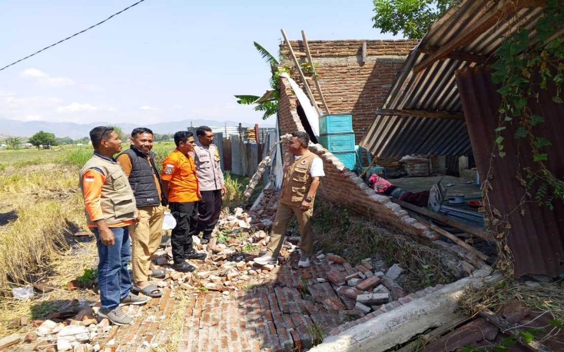
A devastating magnitude 7.7 earthquake struck Indonesia's Flores Island in East Nusa Tenggara province in the early hours of Saturday, leaving at least 38 people dead and triggering urgent rescue operations across the disaster zone. The powerful tremor, which hit at 4.58 am local time with its epicentre located approximately 30 kilometres offshore from Mbay at a depth of 15 kilometres, sent shockwaves through the island and caused widespread structural damage to homes and public facilities.
According to Suharyanto, chief of Indonesia's National Disaster Management Agency (BNPB), the casualty count reflects only the initial assessment conducted in the disaster's immediate aftermath. Beyond those killed, rescue officials recorded two individuals with severe injuries and eleven others sustaining minor wounds. The agency emphasised that these figures remain preliminary, with authorities expecting both casualty and damage assessments to be updated regularly as rescue teams penetrate deeper into affected settlements and conduct thorough surveys of destruction patterns across the island.
The quake's immediate aftermath saw approximately 2,000 residents voluntarily leave their homes and communities, though officials indicated that many more people remained trapped or stranded in areas cut off by infrastructure collapse. Suharyanto stressed during a Saturday press conference that locating and extracting these individuals represents the disaster response's highest priority. Personnel from Basarnas, Indonesia's National Search and Rescue Agency, have been mobilised alongside military and police units to conduct systematic searches through rubble and debris fields.
The initial tsunami warning triggered by the offshore earthquake was fortunately lifted within three hours, after monitoring stations confirmed that sea-level observations showed no dangerous wave activity developing. This swift all-clear prevented what could have compounded the disaster significantly, particularly given Flores's vulnerability to secondary disasters. Residents and evacuees across coastal zones were able to redirect their focus towards terrestrial recovery efforts rather than managing dual emergencies.
Physical destruction across Flores has proven extensive and multifaceted. Dozens of residential structures have been completely or severely damaged, whilst several community health centres sustained substantial harm, potentially compromising medical capacity precisely when emergency care demand peaks. Landslides triggered by ground instability have blocked multiple road corridors, fragmenting access routes and complicating both rescue vehicle movement and supply delivery networks. The island's airport terminal building and two port facilities also sustained damage, though fortunately the airport's runway systems remained operational, preserving air transport as a critical lifeline for emergency personnel and supplies.
The Indonesian government mobilised an extensive logistics and infrastructure response within hours of the disaster. The Public Works Ministry deployed equipment and personnel specifically tasked with clearing landslide-blocked roads, recognising that transport accessibility directly determines rescue effectiveness and humanitarian aid distribution speed. Simultaneously, the BNPB positioned two helicopter units and a fixed-wing aircraft to supplement ground operations, enabling rapid casualty evacuation and coordinated delivery of essential supplies to communities isolated by terrain damage.
Humanitarian assistance convoys have begun distributing food provisions, potable drinking water, clean water supplies for sanitation, emergency tents, electric generators, and other critical items to displaced populations and survivors sheltering in temporary centres. This logistical effort represents a race against deteriorating conditions, as survivors in tropical conditions face acute challenges regarding water access, disease prevention, and shelter from monsoon weather patterns typical for August in eastern Indonesia.
The Flores earthquake carries particular significance for Southeast Asian disaster preparedness discussions, given the region's position along the Pacific Ring of Fire. Indonesia experiences frequent seismic activity due to complex tectonic interactions, yet each major earthquake produces casualties that highlight persistent vulnerabilities in early warning systems, building standards, and disaster response coordination. The relatively swift death toll documentation and rescue mobilisation suggest improved institutional capacity compared to historical disasters, though the continuing discovery of trapped victims indicates that formal response systems remain challenged by the scale of destruction.
For Malaysian and broader ASEAN stakeholders, this disaster underscores the interconnected nature of regional vulnerability. Earthquakes, tsunamis, and resulting humanitarian crises do not respect national boundaries; they generate refugee pressures, cross-border disease transmission risks, and economic disruption affecting regional trade networks. Malaysia's strategic location and developed disaster management infrastructure position it potentially as a destination for evacuees or as a partner in providing technical expertise and medical support to Indonesian recovery efforts.
The Flores earthquake also revives critical questions about building code enforcement and construction standards across developing archipelagic nations. Flores, whilst hosting significant populations in settlements and small cities, has experienced infrastructure development within resource constraints common throughout eastern Indonesia. Retrofitting older structures or establishing earthquake-resistant construction standards requires sustained investment that competes with other development priorities. This tension between safety and development remains unresolved across much of Southeast Asia.

