A powerful magnitude 7.7 earthquake jolted Indonesia's Flores Island in East Nusa Tenggara province early Saturday morning, triggering an immediate crisis response that saw roughly 2,000 residents either evacuated by authorities or independently seeking shelter from the devastating tremors. The quake struck at 4:58 am local time with its epicentre located approximately 30 kilometres offshore from Mbay at a depth of 15 kilometres, unleashing seismic waves that rippled across multiple districts and municipalities throughout the region.
The National Disaster Management Agency, through acting Disaster Data, Information and Communication Centre chief Berton Suar Pelita Panjaitan, confirmed that residents scrambled to safety following the main shock and the subsequent tsunami alert issued by the Meteorology, Climatology and Geophysics Agency. Although the tsunami warning was lifted at 7:31 am after monitoring showed no significant further rise in sea levels, the initial panic had already set the evacuation process in motion across vulnerable coastal and inland communities.
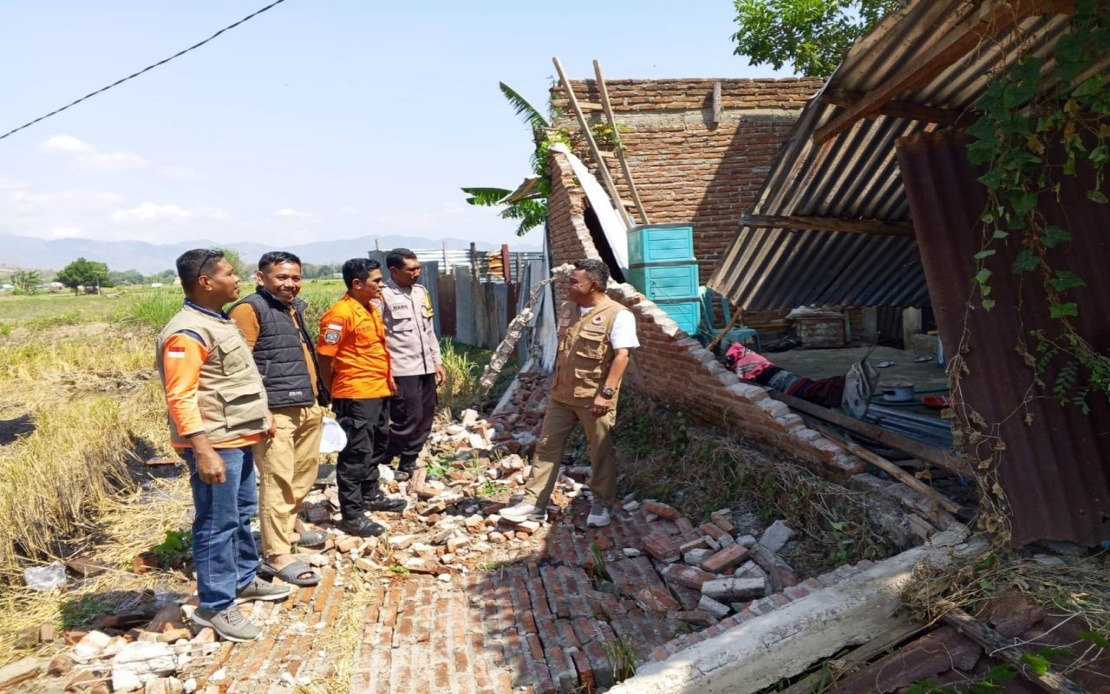
Structural damage assessment reveals a concerning pattern of destruction across the affected territories. Preliminary surveys documented 54 houses sustaining severe damage, nine suffering moderate harm, and 11 experiencing minor structural compromise. Beyond residential properties, critical infrastructure has also been compromised, including five health facilities, one educational institution, three places of worship, one storage facility operated by state food logistics agency Bulog, and six government offices, collectively hampering emergency response capabilities and essential services delivery.
The Manggarai district, located on Flores itself, bore the brunt of the destruction, with 29 houses reduced to severe damage, nine moderately affected, and another nine sustaining minor injuries. Neighbouring East Manggarai recorded 23 severely damaged residences, indicating that the earthquake's destructive force concentrated heavily across western and central portions of the island. Disaster management officials emphasised that field assessments were ongoing, with regional agencies, military personnel, police forces, and local administrations continuing systematic documentation and verification of losses.
The death toll from the earthquake and subsequent powerful aftershocks has reached 20 individuals, with six others injured and two remaining trapped beneath rubble, according to reports from the Maumere Search and Rescue Office. The series of 111 recorded aftershocks kept residents on edge throughout the day, complicating rescue efforts and deterring many from returning to damaged structures, thereby extending the displacement crisis beyond the immediate post-quake hours.
The earthquake's impact extended beyond physical destruction into the telecommunications sector, a critical vulnerability in disaster response scenarios. The Communication and Digital Affairs Ministry identified 200 base transceiver station sites across 10 districts and cities experiencing service disruptions as of 7 am local time. Digital Infrastructure director-general Wayan Toni Supriyanto noted that the affected installations represented 16.35 per cent of all BTS sites in the impacted areas, compromising both emergency communications and civilian access to information during the crisis.
For Malaysian and broader Southeast Asian observers, the Flores earthquake underscores the persistent seismic vulnerability that characterises the region's geological positioning along the Pacific Ring of Fire. Indonesia sits among the world's most earthquake-prone nations, with the Flores region specifically positioned along a complex intersection of tectonic plates that generate frequent seismic activity. The rapid mobilisation of rescue and assessment teams demonstrates improving disaster response protocols, yet also highlights infrastructure fragility in remote island communities where geographic isolation complicates humanitarian access.
The displacement of 2,000 residents raises immediate humanitarian concerns regarding shelter, food security, and healthcare access, particularly given the simultaneous damage to health facilities and the ongoing psychological trauma from continuous aftershocks. Emergency coordination amongst regional disaster agencies, military forces, police departments, and local authorities represents the standard response architecture, though the scale of need typically outpaces initial resource availability in such events.
Telecommunications restoration becomes paramount not merely for commercial reasons but for enabling stranded survivors to contact relatives and for coordinating logistics of aid distribution. The ministry's coordination with mobile operators to restore services addresses a critical gap in disaster management, as communities isolated by both distance and broken infrastructure face compounded vulnerability. This technical dimension of disaster response often receives less public attention than rescue operations, yet proves equally essential for effective humanitarian outcomes.
The earthquake's timing and intensity serve as a reminder of the precarious balance between geological forces and human settlement patterns across Southeast Asia. Regional governments and development agencies continue wrestling with fundamental challenges: how to develop earthquake-resilient building codes in economically constrained areas, how to maintain functional warning systems and evacuation routes, and how to ensure adequate post-disaster support for displaced populations. The Flores event will likely inform upcoming disaster preparedness reviews across Indonesia's eastern provinces and potentially shape regional discussions about seismic risk management within ASEAN frameworks.
Beyond the immediate response phase, the long-term recovery trajectory depends significantly on international and domestic resource mobilisation, reconstruction planning that incorporates improved building standards, and community resilience initiatives that prepare populations for future inevitable seismic events. The assessment teams currently documenting damage will eventually generate detailed reports informing reconstruction priorities and policy adjustments aimed at reducing vulnerability in subsequent disasters.

