The Malaysian Meteorological Department has activated weather alerts across a significant swathe of the country, cautioning residents in eight states to prepare for potentially hazardous conditions through the early evening. The advisory encompasses regions spanning Peninsular Malaysia, Sarawak, and Sabah, reflecting a broad atmospheric disturbance affecting the nation's weather patterns at a critical time during the southwest monsoon transition period.
Northern Peninsular Malaysia faces considerable exposure, with residents across multiple districts in Kedah placed on alert. The affected areas include Kota Setar, the state capital, alongside Yan, Pendang, Kuala Muda, and Sik—communities that collectively house hundreds of thousands of residents. Perak's administrative heart also features prominently on the warning list, with the municipalities of Manjung and Perak Tengah expected to experience severe weather, creating potential disruption across one of the nation's industrial and commercial hubs.
The central region faces similar threats to atmospheric stability. Terengganu's Kemaman district, Pahang's Kuantan municipality, and Selangor's Hulu Langat jurisdiction all fall within the affected zone. Negeri Sembilan's districts of Jelebu and Seremban round out the Peninsular coverage. This geographic spread indicates a weather system of considerable scale and intensity, posing risks to transportation networks, outdoor activities, and critical infrastructure across these densely populated areas.
East Malaysian territories are equally vulnerable. In Sarawak, forecasters identified Sarikei (which encompasses Sibu division) and Mukah (covering Tanjung Manis and Daro) as particularly exposed. Sabah's warning extends across multiple divisions reflecting the state's geographic diversity: the Interior Division includes Keningau and Tambunan, while the West Coast Division encompasses Papar and Penampang. Sandakan district's Kinabatangan area completes the Sabahan coverage. The inclusion of these regions suggests the atmospheric disturbance carries sufficient intensity to traverse the geographical barriers presented by Borneo's terrain.
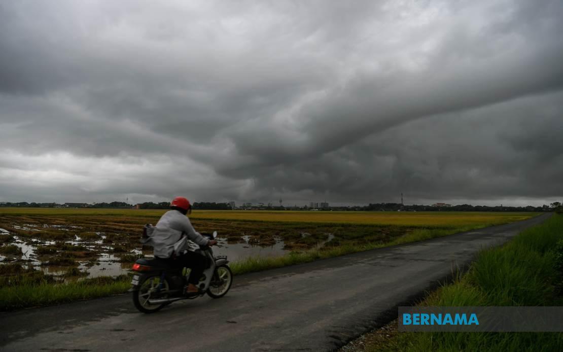
The forecast combines three distinct hazards that together demand heightened public vigilance. Thunderstorm activity creates immediate lightning risks, particularly concerning for communities engaged in outdoor occupations or recreational activities. Heavy rainfall compounds these dangers by elevating flood risk in low-lying areas, potentially overwhelming drainage infrastructure and creating hazardous travel conditions. Strong wind gusts, the third component of the warning, threaten unstable structures and present collision hazards for high-sided vehicles on exposed highways and bridges.
For Malaysian residents and businesses, such alerts carry practical implications that extend beyond mere weather inconvenience. Flash flooding frequently overwhelms drainage systems in urban areas, particularly in flash-prone zones identified during previous monsoon seasons. Commuters face extended travel times and safety risks on major routes, while construction sites and outdoor manufacturing operations typically halt work to protect personnel and equipment. The financial impact of halted productivity across multiple states accumulates rapidly when weather warnings span several hours during business days.
The temporal limitation of this alert—expiring at 6 pm—suggests forecasters anticipate the weather system's intensity will diminish by evening as atmospheric pressure patterns evolve. This relatively short window means the most dangerous conditions concentrate during afternoon hours, precisely when traffic volumes peak and many outdoor activities continue. Residents in affected areas should monitor subsequent updates closely, as MetMalaysia routinely extends or modifies alerts based on evolving atmospheric data.
The geographic scope of this warning reflects the complex interplay between monsoon circulation patterns and local topographic influences characteristic of tropical maritime climates. During transitional periods between monsoon regimes, atmospheric instability often manifests across broad regions simultaneously, creating the multi-state impact visible in this alert. Understanding these seasonal patterns helps residents and emergency planners anticipate heightened weather volatility during specific calendar periods.
For travelers and logistics operators, the alert necessitates route planning adjustments and schedule flexibility. Airlines and maritime operators monitor such advisories carefully, as the combination of thunderstorm activity and strong winds creates operational challenges. The warning's specificity regarding affected districts enables local authorities to pre-position resources and activate communication channels to notify residents proactively.
Public safety authorities typically escalate response protocols during such widespread weather alerts. Fire and rescue services stand by for emergency calls related to weather impacts, while local government agencies prepare drainage maintenance equipment and coordinate with utility providers to address potential infrastructure disruption. Schools and public institutions in affected areas may implement contingency arrangements if conditions deteriorate severely.
The issuance of this warning demonstrates MetMalaysia's systematic approach to public communication during significant weather events. By clearly identifying specific districts rather than merely naming states, the department enables residents to assess personal risk more accurately and take proportionate precautions. Such precision in meteorological communication represents best practice for tropical countries where localized weather phenomena often determine actual impact levels.
Residents within the specified areas should secure loose outdoor objects, avoid unnecessary travel during peak warning hours, and monitor local media for updates. The relatively short duration of this alert suggests the weather system will pass through without extended disruption, though residents should remain vigilant until the 6 pm deadline passes. Post-alert conditions warrant attention to local drainage conditions and potential flooding in historically vulnerable areas as accumulated rainfall drains through infrastructure systems.