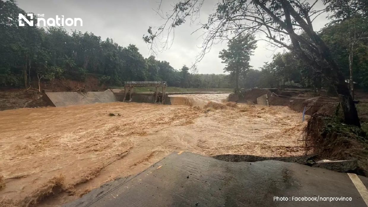
Northern Thailand confronted a natural disaster of significant scale in the early hours of Wednesday when Pua district in Nan province fell victim to devastating flash flooding triggered by extraordinarily heavy overnight rainfall. The Doi Phu Kha National Park office recorded precipitation levels surpassing 110mm, a volume substantial enough to generate dangerous runoff across multiple populated areas. The flooding marks the latest in a recurring pattern of water-related catastrophes that regularly strike Thailand's northern regions during monsoon season, underscoring the vulnerability of communities positioned in headwater zones where geographical features concentrate rainfall into torrential flows.
The meteorological conditions that produced this disaster developed overnight in Phu Kha subdistrict, a heavily forested region at high elevation where natural catchment characteristics amplify water accumulation. Residents and local authorities received formal notification of the crisis around 6am, by which point water had already infiltrated residential neighbourhoods and agricultural properties across several communities. The rapid onset of the flooding left many families with minimal opportunity to secure their possessions, relocate livestock, or transport vulnerable household members to safer locations before water levels rose sufficiently to enter their homes. The combination of speed and volume created conditions where residents prioritised personal safety over protecting property.
Communities scattered throughout the Pua administrative area experienced varying degrees of damage. Ban Rong, situated within Pua subdistrict, ranked among the hardest-hit settlements, whilst Ban Na Lae, positioned along the primary route towards Doi Phu Kha National Park and Bo Kluea district, suffered catastrophic infrastructure loss when floodwaters destroyed a critical bridge spanning a waterway. The absence of this crossing rendered the road completely unusable, effectively isolating communities downstream and preventing access to essential services including healthcare, provisions and emergency assistance. Such infrastructure damage typically requires weeks or months for remediation, creating prolonged disruption to regional commerce and mobility.
The flooding's destructive footprint extended beyond inundated villages into the transport network that connects Pua to surrounding districts. Authorities operating under the Department of Highways, specifically the Nan Highway District 2 division, conducted surveys immediately after water receded and identified three separate locations where road surfaces sustained damage sufficient to prevent vehicle passage. These obstructions combined with the destroyed bridge at Ban Na Lae to effectively isolate the affected zone from rapid resupply or evacuation routes. The Fai Chao weir area also witnessed bridge destruction, compounding the infrastructure crisis. Travellers attempting to navigate toward Pua encountered multiple closed roads, forcing significant detours around affected corridors.
Geographical instability accompanied the flooding, as the tremendous volume of water and saturation of ground surfaces triggered landslides in Ouan subdistrict. These secondary disasters blocked additional routes and created hazardous conditions that complicated rescue and recovery operations. The combination of standing floodwater, destroyed infrastructure and active landslide risk produced an environment where official responders required substantial time to reach isolated communities and assess full damage extent. Such cascading natural hazards are characteristic of flash flood events in Thailand's northern terrain, where mountainous topography and intensive rainfall create interconnected vulnerabilities.
The Nan Provincial Disaster Prevention and Mitigation Office mobilised to coordinate response efforts, though the rapid escalation of conditions outpaced initial assessment capabilities. Officials committed to issuing updated situation reports as circumstances developed, acknowledging that the full scope of damage and displacement remained unclear during the early response phase. This institutional framework represents Thailand's designated mechanism for coordinating disaster response at provincial level, yet the scale and speed of Wednesday's flooding strained these established structures.
Automation and technology augmented human-centred response efforts when the Department of Disaster Prevention and Mitigation worked through mobile network operators AIS, True and NT to broadcast emergency alerts via the Cell Broadcast system. This alert system reached mobile phones throughout Pua district with urgent guidance for residents. The message conveyed by authorities emphasised immediate protective actions, instructing residents to transfer belongings to elevated locations and directing individuals responsible for elderly people and bedridden patients to evacuate these vulnerable populations. Contact information for subdistrict administrative officials and village leadership provided residents with channels for requesting evacuation assistance or reporting unmet humanitarian needs. This coordinated alert system demonstrated the integration of telecommunications infrastructure into Thailand's disaster response architecture.
The Northern Meteorological Centre of the Thai Meteorological Department identified that radar equipment operated by the organisation detected precipitation patterns affecting nine provinces across upper northern Thailand. Rain bands were moving systematically toward the south-west, suggesting that additional communities beyond those already impacted faced potential exposure to heavy rainfall in subsequent hours. This meteorological trajectory presented the possibility that neighbouring districts might experience comparable flooding conditions, potentially stretching emergency response capacity across a wider geographical area than initially anticipated during the peak Pua crisis.
The events in Pua district resonate across Southeast Asia as a reminder of climate-related vulnerabilities affecting the region. Thailand's northern provinces, encompassing Nan, Lamphun and adjoining jurisdictions, experience regular seasonal flooding that has grown increasingly severe, according to climatic trend analyses. Communities in Pua and surrounding areas possess limited infrastructure resilience, with bridges and roads designed to nineteenth and twentieth-century engineering standards now facing intensified water flows resulting from evolving precipitation patterns. The relatively frequent occurrence of such disasters suggests that permanent solutions require sustained investment in modern drainage systems, reinforced bridge structures and early warning mechanisms that provide adequate time for population movement.

