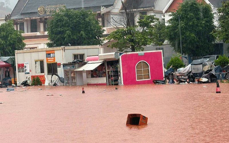
The northern Laotian province of Luang Namtha has been officially designated a disaster zone following catastrophic flash floods that inundated the Boten border crossing with China on Saturday, August 29. The provincial administrative authority made the declaration after water from swollen upstream tributaries cascaded southward into the region, submerging buildings across more than 30 villages while damaging critical infrastructure, farmland, and a special economic zone. Despite the severity of the flooding throughout the border area, officials confirmed that the border checkpoint itself remained operational and unaffected by the rising waters.
The immediate impact of the deluge extended far beyond isolated communities. Structures situated near watercourses were partially or completely submerged, while educational institutions, healthcare facilities, and the provincial airport all suffered damage or disruption. Luang Namtha and Nalae districts bore the brunt of the disaster, with widespread inundation accompanied by dangerous landslides that threatened homes and blocked transportation routes. The breadth of the affected area underscores how vulnerable the province's scattered settlements remain to hydrological crises, particularly given the concentration of villages in low-lying areas susceptible to rapid water overflow during monsoon periods.
Hydrometeorological monitoring stations revealed the severity of the water surge with precision. The Tha River's flow exceeded critical thresholds dramatically, with measurements at a key gauging station recording 6.58 metres on Saturday—surpassing the official 6-metre alert level and edging dangerously close to the 7-metre benchmark at which catastrophic flooding becomes inevitable. These readings reflected days of unrelenting heavy rainfall throughout the upstream catchment area spanning both northern Laos and adjacent regions of southwestern China, where the same weather system had triggered widespread precipitation. The rapid rise demonstrated the interconnected nature of cross-border hydrology in mainland Southeast Asia, where rainfall hundreds of kilometres away can translate into life-threatening conditions within hours.
In response to the escalating crisis, the Department of Meteorology and Hydrology issued formal flood warnings specifically for the Tha River system covering August 29 and 30. Provincial authorities across Luang Namtha subsequently mobilised five district administrations to activate emergency communication protocols, instructing officials to notify all residents inhabiting riverbank communities and topographically vulnerable areas to prepare evacuation procedures immediately. The emphasis on preparedness rather than reactive response reflected lessons learned from previous disasters, recognising that early warning systems are only effective when coupled with decisive community mobilisation and accessible escape routes.
The government instructions to local administrators revealed the scope of coordination required to manage such widespread emergencies. Officials received explicit directives to maintain constant surveillance of water levels and weather conditions, respond swiftly to developing emergencies as they arose, and furnish regular status updates to provincial headquarters. This hierarchical reporting structure, broadcast through state media, signalled recognition that the August 29-30 period represented a critical window during which conditions could deteriorate further or stabilise depending on whether rainfall intensity decreased. The chain of command reflected administrative awareness that delayed information flow in remote border areas could prove fatal to stranded communities.
The Luang Namtha crisis forms part of a substantially broader weather emergency affecting the Lao PDR's entire northern tier and extending into adjacent regions. Fourteen provinces have been placed under heightened alert status as a powerful low-pressure system positioning itself across northern Laos and southwestern China combines with the southwesterly monsoon circulation to generate organised bands of thunderstorm activity. This meteorological configuration typically produces not merely scattered rainfall but intense convective precipitation concentrated over mountainous terrain where topography amplifies vertical motion and enhances rainfall rates. The provinces at risk span the full width of northern and central Laos: Phongsaly, Huaphan, Luang Prabang, Luang Namtha, Oudomxay, Xaysomboun, Bolikhamxay, Khammuan, Savannakhet, Salavan, Xekong, Champasak, Attapeu and Vientiane.
The convergence of multiple meteorological forcing mechanisms presents a particularly hazardous scenario for densely populated riverine settlements throughout the region. Beyond heavy rainfall, the forecast included moderate to strong winds that could compound structural damage and impede rescue operations. Landslides represent an equally serious secondary hazard, as saturated slopes throughout Laos's mountainous geography become mechanically unstable during extreme rainfall events. For Myanmar, Thailand, and Malaysian observers monitoring the regional situation, the Lao floods serve as a reminder that severe weather systems crossing mainland Southeast Asia often simultaneously threaten multiple countries, requiring coordinated cross-border warning systems and humanitarian response mechanisms.
Officials have urged communities living proximate to rivers and occupying topographically low-lying areas to maintain vigilant monitoring of weather forecasts and to treat all flood and landslide warnings with appropriate urgency. This messaging, disseminated through state broadcasting channels, represents an attempt to institutionalise individual protective behaviour across dispersed rural populations who may possess limited prior experience with formal early-warning systems. The appeal to situational awareness reflects the reality that in remote border communities, official guidance often reaches residents through word-of-mouth and local administrative channels rather than through media consumed in urban centres. Enhanced vigilance by individual households and community leaders therefore constitutes an essential final line of defence against catastrophic loss of life when hydrological emergencies strike with minimal advance notice.

