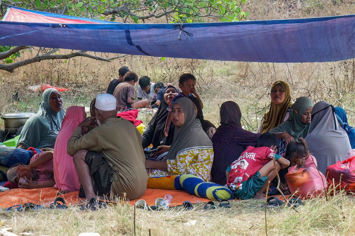
Thousands of displaced residents across Indonesia's Flores island remained in makeshift shelters on Sunday, struggling without adequate supplies following a catastrophic 7.7-magnitude earthquake that claimed 48 lives and triggered hundreds of aftershocks. The powerful tremor struck early Saturday with its epicentre positioned just offshore from the island's northern coastline, catching residents off-guard and forcing a mass evacuation that saw approximately 5,000 people abandon their homes within hours. By Sunday morning, survivors were still occupying hillsides and open spaces throughout affected communities, too frightened and traumatised to return to damaged dwellings as seismic activity continued to rattle the region.
The earthquake unleashed a relentless barrage of aftershocks numbering 341 in the immediate hours following the initial impact, according to BNPB national disaster agency spokesman Berton Suar Pelita Panjaitan. This sustained seismic activity kept residents in a state of heightened anxiety and prevented hasty returns to potentially unstable structures. The shallow nature of the quake amplified its destructive capacity across the island, with particular intensity concentrated in communities along the northern coast. Search and rescue operations continued throughout Sunday, though local officials indicated no persons had been reported as buried or missing, allowing authorities to shift focus toward locating survivors and establishing evacuation centres.
The human cost extended beyond immediate fatalities. At least 101 residents sustained injuries requiring medical attention, with many requiring urgent hospitalisation. Infrastructure damage compounded the humanitarian crisis, as entire villages found themselves isolated without electricity or telecommunications connectivity. Critical access routes remained blocked or severely compromised, hindering the delivery of emergency supplies to the most vulnerable populations. Communities in coastal areas additionally faced the terrifying prospect of tsunami activity, as residents reported seeing the sea retreat during the initial earthquake—a telltale warning sign that prompted spontaneous mass movement toward higher ground before the tsunami warning was ultimately lifted.
Physical destruction across Flores proved extensive and varied. Official assessments identified at least 914 residential structures sustaining severe damage sufficient to render them uninhabitable, with hundreds of additional properties experiencing moderate to light damage. Beyond homes, the earthquake targeted critical community infrastructure including 93 educational facilities, 36 health centres, and 38 government offices. Residents like Umri from Nangahale village articulated the immediate survival challenges facing displaced communities: food shortages, potable water scarcity, inadequate medicine supplies, and the absence of basic childcare items. Nurhidayati, a 55-year-old survivor sheltering on an exposed hillside, conveyed the profound psychological toll the disaster exacted, particularly among residents carrying memories of the devastating 1992 Flores earthquake that killed approximately 2,500 people and triggered a tsunami.
The 1992 precedent weighed heavily on survivors' consciousness, amplifying collective trauma and reluctance to return home despite aftershock frequency diminishing. Residents harboured justifiable concerns about structural integrity following successive seismic waves and feared that remaining aftershocks could precipitate building collapses. This psychological dimension of disaster response frequently receives insufficient policy attention despite fundamentally shaping recovery trajectories and community resilience. The trauma manifested across age groups and affected both immediate physical responses and longer-term mental health considerations that humanitarian agencies would need to address throughout reconstruction.
Government mobilisation accelerated rapidly despite coordination challenges inherent to rapid-onset disasters affecting remote island regions. The East Nusa Tenggara provincial government initiated emergency declaration proceedings targeting a 14-day emergency response status, establishing the administrative framework for accelerated resource allocation and authority concentration necessary during crisis management. The national government dispatched 50,000 aid packages totalling 275 tonnes to affected areas, representing a substantial logistical undertaking requiring coordination across multiple agencies and transport modes. The BNPB formally identified priority assistance requirements encompassing emergency shelter provisions, food distributions, medicine stocks, blankets, camp beds, sleeping mats, clean water supplies, and electricity generation capacity.
The international community mobilised support mechanisms within hours of the disaster confirmation. The International Federation of Red Cross and Red Crescent Societies activated preparedness protocols and began coordinating aid movements toward temporary shelter locations. European Union leadership notably offered technological assistance through the Copernicus Earth observation satellite network, providing real-time imagery and damage assessment capabilities that could enhance search and rescue operation efficiency. This satellite deployment represented a contemporary dimension of disaster response that leveraged advanced geospatial technology to complement ground-based rescue efforts and inform resource prioritisation decisions.
Flores occupies a strategically vulnerable position within Indonesia's seismic landscape. The island sits within the Pacific Ring of Fire, the extensive arc of tectonic plate boundaries and volcanic systems extending from Japan through Southeast Asia across the Pacific basin. This geographical positioning ensures Indonesia's perpetual exposure to significant seismic activity as a consequence of fundamental planetary geology. The 1992 Flores earthquake established historical precedent for major seismic events affecting this specific region, while the 2004 Indian Ocean earthquake and tsunami—a 9.1-magnitude catastrophe centred off Sumatra's coast—demonstrated the region's capacity to experience truly unprecedented disasters. That 2004 event killed approximately 220,000 people across the Indian Ocean region, with roughly 170,000 deaths concentrated within Indonesia, establishing it among history's deadliest natural disasters and illustrating the existential threat seismic and tsunami hazards pose to Southeast Asian populations.
The Flores earthquake occurred within Indonesia's broader context of natural disaster exposure and institutional response capacity development. Successive major seismic events throughout the archipelago have motivated incremental improvements in early warning systems, building code enforcement, and disaster management protocols. Yet implementation remains inconsistent across regions, with island communities frequently facing capacity constraints relative to urban centres. Flores's relatively underdeveloped infrastructure, limited high-rise construction that might demonstrate advanced seismic engineering, and scattered settlement patterns created conditions where earthquake impacts dispersed across numerous small communities rather than concentrating in urban epicentres. This distribution pattern complicated coordination of rescue and relief operations while extending logistical demands across broader geographical areas requiring multiple supply distribution points.
The disaster's implications extended beyond Flores itself to inform regional preparedness assessments and Malaysian considerations of seismic risk management. Malaysia's own locations, particularly Sabah and Sarawak, face comparable tectonic exposures that merit continuous evaluation of building standards and evacuation protocols. The Flores experience underscored the criticality of maintaining robust early warning systems, ensuring adequate emergency stockpiling, and establishing pre-disaster coordination frameworks that enable rapid humanitarian response activation. Regional cooperation mechanisms including ASEAN disaster management protocols assumed heightened relevance following incidents demonstrating how comprehensively natural disasters could overwhelm individual national response capacities, particularly in island and peripheral communities with limited pre-positioned resources.

